Advanced Technology Developers for Precision Agriculture
The geo-monitoring tools for Precision Agriculture help growers locate the farms’ soil nutrients, water requirements, temperature mapping, and rain gauge, among other parameters. The article focus on the technological solutions available in the market and representative technology developers of such precision agriculture tools.
Technology Developing Startups
Real-time, continuous monitoring of agriculture crops and soil health enables accurate forecasting of crop yields. When coupled with weather forecasts, this data can predict commodity prices and possible risks in the food supply, reducing global food insecurity.
Technology integration using low-cost agriculture sensors, GPS tracking, and IoT platforms can potentially enhance data collection, real-time insights, and process automation. The farming and agriculture industry can benefit through such integration. We already see farmers, Agricultural Technology (AgTech) leaders, and Food & Beverage (F&B) corporates collaborating with technology developers to explore the geo-monitoring tools.
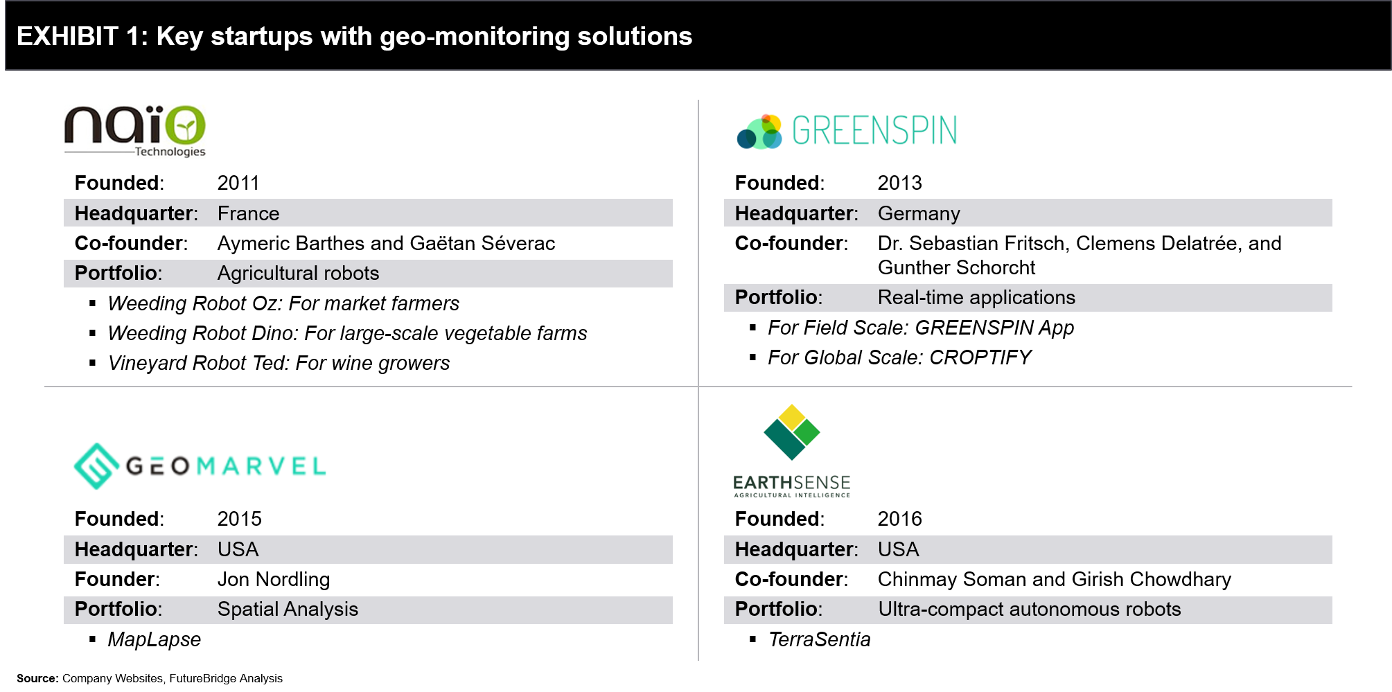
Exhibit 1 illustrates a few of the selected startups with high funding and integrated agriculture technologies.

Naïo Technologies
Founded in 2011, Naïo Technologies develops robotic solutions for farming practices. The company received multiple rounds of funding to launch and test its robots. Its first fundraiser in 2013 raised €60.000 to launch its first series of Oz robots. In 2014, it raised a further €750.000 through Angel investors and a crowdfunding campaign to expand Oz robots’ manufacturing and marketing. In 2015, it raised €3 million for the technical and commercial development of robots in France and abroad. Currently, Naïo Technologies is focusing on the study of prototypes for large-scale vegetable production and vineyards.
One of its products, TED, is an autonomous weeding system integrated with a GPS RTK guidance system. Plots are mapped automatically with a photographic drone, and the system works with centimeter precision and without any assistance. The robot follows a simple working method: Plot mapping using drone and GPS data tracking on every vineyard plot. Its other product, Dino, has combined TED’s feature with the additional capability to detect the type of crops planted in the farm, which aids in better planning for plantation.
green spin GmbH
green spin, founded in 2013, develops applications and solutions for digitalization and optimization of processes in the agricultural sector. The company is a spin-off from the Department of Geography of the University of Würzburg, co-founded by three alumni/scientists: Dr. Sebastian Fritsch, Clemens Delatrée, and Gunther Schorcht to develop and provide open geospatial data to improve agricultural systems.
The company was incubated at ESA BIC Bavaria from 2013 to 2015. green spin’s technology – mofato integrates big data, scaling, speed, and spatial intelligence to develop algorithms capable of providing real-time data. The company’s clientele includes government as well as corporates such as Syngenta.
GeoMarvel
Founded in 2015, GeoMarvel is a software development company and Esri partner. It specializes in GIS-focused workforce optimization, cloud computing, data analysis, and custom application, and data visualization development.
Its technology and spatial analysis help reveal hidden patterns and trends related to soil health, soil erosion, soil moisture, nutrient deficiencies, crop health, among other outputs. It also uses remote sensing to monitor crops and map crop production.
EarthSense
Since its inception in 2016, EarthSense, which develops small robots to create new farming possibilities, has raised around $50,000. TerraSentia, its first robot, can improve the quantity, accuracy, cost, and speed of in-field plant trait data collection, improving the possible precision from aerial data. The technology processes data from RGB cameras and optical sensors, including LiDAR using machine learning-based analytics to seamlessly convert the field data into specific, actionable information about plant-traits.
During its 2018 Early Adopter Program, the company sold 25 robots. In 2019, the company successfully improved TerraSentia hardware, software, and analytics based on these pioneering users’ experiences.
References


 4 min read


